1/2


ดาวน์โหลด1K+
Rating0
ขนาด192kB
Age PEGI-3
เวอร์ชั่นแอนดรอยด์2.2.x+
รายละเอียดรีวิวเวอร์ชั่นข้อมูล
1/2
คำอธิบายของRF Planner
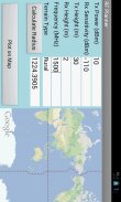
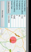
This is a simple application which can be used to do RF planning of a GSM, WCDMA, LTE or WiMAX site. The input parameters are the Tx Power, Rx Sensitivity, Tx Height, Rx Height and Frequency of operation. The output parameter is the Cell Radius which is used to plot the coverage area of the cell site on Google Maps. The coverage scenario can be selected from the following three options:
1. Urban
2. Suburban
3. Rural
The underlying model is applicable to Frequencies of up to 3500 MHz, Distances of 100-8000 m, BS Antenna Heights of 10-80 m and MS Antenna Height of 2-10 m.</div> <div jsname="WJz9Hc" style="display:none">นี้เป็นโปรแกรมที่ง่ายซึ่งสามารถใช้ในการทำการวางแผน RF ของ GSM, WCDMA, LTE หรือเว็บไซต์ WiMAX ป้อนพารามิเตอร์เป็นพลังงาน Tx, Rx ไว Tx ความสูงความสูง Rx และความถี่ของการดำเนินงาน พารามิเตอร์ที่ส่งออกเป็นรัศมีของเซลล์ที่ใช้ในการวางแผนพื้นที่ของเว็บไซต์มือถือบน Google Maps สถานการณ์ความคุ้มครองที่สามารถเลือกได้จากตัวเลือกต่อไปนี้สาม:
1. เมือง
2. ชานเมือง
3. ชนบท
รูปแบบพื้นฐานใช้ได้กับความถี่สูงสุดถึง 3500 MHz, ระยะทางของ 100-8,000 เมตร, BS เสาอากาศของไฮ 10-80 เมตรและ MS เสาอากาศความสูง 2-10 เมตร</div> <div class="show-more-end">
RF Planner--เวอร์ชั่น1.0
(13-06-2016)RF Planner - ข้อมูล APK
เวอร์ชั่น APK: 1.0แพ็คเกจ: com.raymaps.rf.planner1ชื่อ: RF Plannerขนาด: 192 kBดาวน์โหลด: 27เวอร์ชั่น : 1.0วันที่ปล่อย: 2020-05-18 15:38:02หน้าจอขั้นต่ำ: SMALLCPU ที่รองรับ: ID ของแพคเกจ: com.raymaps.rf.planner1ลายเซ็น SHA1: 35:31:BF:12:2B:F3:CA:D8:19:8C:60:E9:74:9F:8A:69:76:5C:77:BFนักพัฒนา (CN): Yasir Ahmedองค์กร (O): RAYmapsท้องถิ่น (L): Islamabadประเทศ (C): รัฐ/เมือง (ST):
เวอร์ชั่นล่าสุดของRF Planner
1.0
13/6/201627 ดาวน์โหลด192 kB ขนาด


Merge County® 4.63
4.63
4.63แอปในประเภทเดียวกัน
 4.284.463.374.073.722.38
English


